


![]()
1. I Don’t See My Result
- If you don’t see your result on the official results (the ones that appear on Eventor) then the most likely cause is that you don’t have a result on the MapRun leaderboard. In this case see 2. below.
If you do have a result on MapRun leaderboard but not on Eventor then most likely it hadn’t appeared on leaderboard at the time that the results were taken from MapRun (usually around 9pm on Wednesday evening). In this case please let the Street O Admin people know that your result wasn’t captured by sending an email to
This email address is being protected from spambots. You need JavaScript enabled to view it. - If after your run you don’t see your result on the MapRun leaderboard it could be because:
- For some reason, MapRun hasn’t automatically uploaded your result to the MapRun server. In this case the solution is to do a manual upload. To do this:
- Go into MapRun on your phone
- Select Show Results
If your result hasn't been uploaded then at this stage it will show you your route on the map. If so, select the (hamburger) menu in the top right of the screen. In that menu there is an option to Upload (manual).
- For people using MapRunG, it could be that your watch has a lot of activities from your previous training efforts that are being uploaded to Garmin Connect. The solution in this case is just to be patient. Eventually your run from the day will be uploaded to Garmin and will be available to use as the track to upload to the MapRun leaderboard.
2. HITMO (Hey, I Think It Missed One!)
If you are absolutely sure that you went to the centre of the circle for a control but it didn’t register in your MapRun app, when you have finished you can let the organisers know by using the HITMO function in MapRun.
- From the main MapRun screen select the “Show Results” button.
Your track from the event should be showing. Controls that are coloured green are the controls that have been included in your result. - From the Results screen press the (hamburger) menu at the top right of the screen.
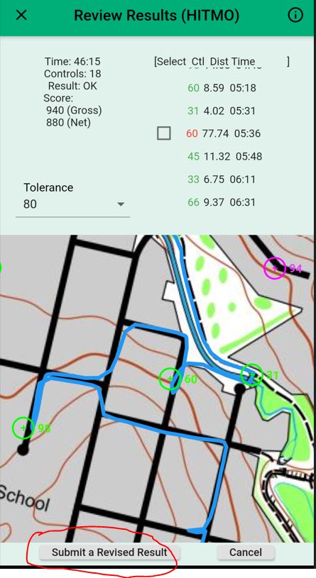
- Select Review Results (HITMO).
You will see a list of controls that you passed within the Tolerance specified. The default setting for this tolerance is 30 metres. In this list the controls that are included in your score are in green. Controls that aren’t in your score are in red. Pressing on a control in this list will centre the map on that control.
If you feel that a red control should be in your result press the Check box next to the control and then press the “Submit A Revised Result” button at the bottom of the screen.
Notes:
- If you don’t see the list of controls on your screen it might be because you have the font size setting on your phone set to be too large.
- In the example shown, control 60 appears in red. However this should NOT be checked since this was me passing control 60 within the set tolerance as I was running to the north along the path away from control 31. (To get this to happen I had to set the tolerance 70m!) Notice that control 60 had already been included in the results from when I actually visited the correct control site.
The revised result that you have submitted will appear in the results with a “(Rev xx)” (where xx is the tolerance you used) next to your name. When the organisers go through the results they will make a determination (by looking at the trace of your run) of which one of your two entries to be your official result.
3. My Phone is not Working
If for some reason your phone is not working (e.g. the battery is flat) you can still get an official run if you have a GPS watch.
- Record your run using your GPS watch. Make sure that you go to the centre of each circle (i.e. to the feature described in the control descriptions).
- After your run, extract your run as a gpx file. (Just how you do this will vary according to the brand of watch that you are using.)
- Send the gpx file via email to Street-O Admin at This email address is being protected from spambots. You need JavaScript enabled to view it.
In the email please let Street-O Admin know the year of your birth. This is part of the information that MapRun requires (so that it can put you in a category).
4. Animation
When you view your track through MapRun you can also view an animation of your run. Click on the “Load Animation” button and then press the “Start” button.
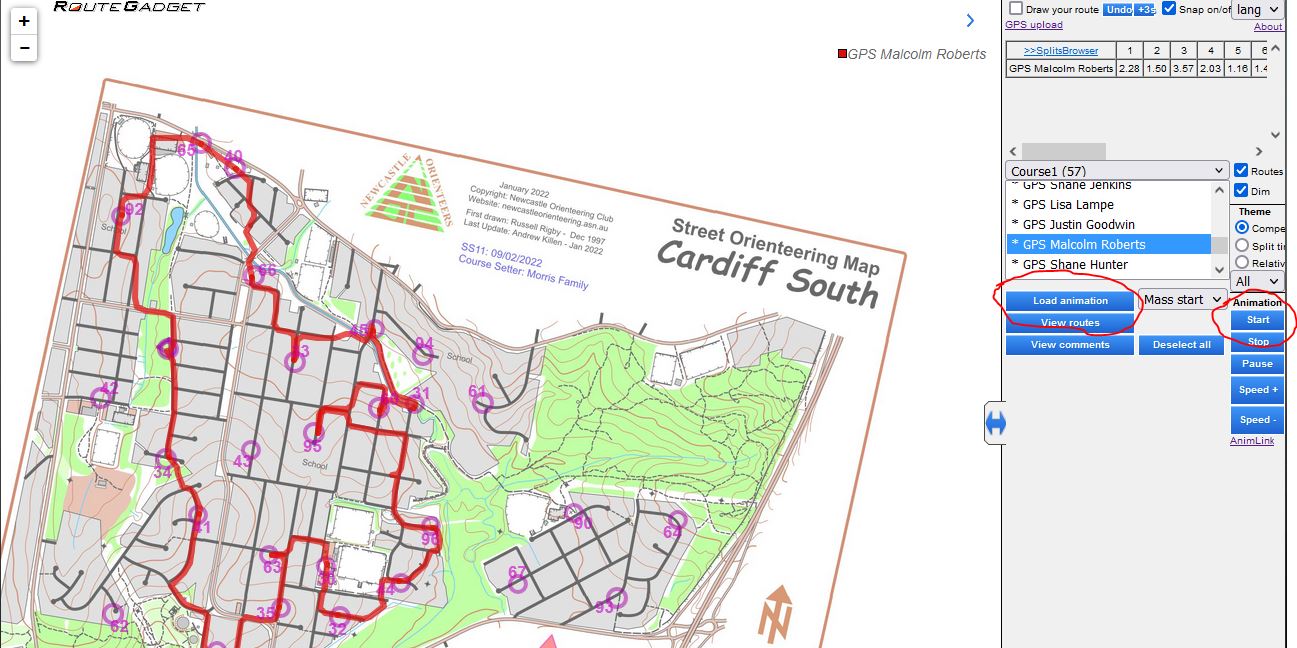
For even more fun select a few other runners, presumably your closest rivals, (if you are on a computer do this by holding down the Ctrl key and clicking on their names in the list of all competitors)), load the animation and start it going. You can even select the whole field (again on the computer, select the first competitor in the list, scroll to the last competitor, hold down the Shift key and select the last competitor) and see the whole event in the one animation!
![]()
Street-O and BOSS events use the smartphone GPS app called MapRun.
MapRun is a free app for orienteering which uses GPS to record your visit to controls on a course. The MapRun app on your phone (or smartwatch) automatically registers your visit when you reach each control location.
Setting up the App
- Download (free from Apple App Store or Google Play) the MapRun app and install it on your smartphone.
Note: Make sure that you get MapRun (current version 7) and not either of the previous versions of the app which were called MapRunF and MapRun6. - Open the app and fill in the required personal details
- Optional: If you have a suitable Garmin or Apple smartwatch you can also download an app onto your watch (MapRunG for Garmin or MapRunA for Apple Watch). This allows you to run the event using your smartwatch instead of carrying your phone (although you will still need MapRun on your phone).
- Ensure that you have set the Settings on your phone for Location (for MapRun) to "while using the app".
- Ensure that your data is turned on.
Using MapRun at an Event
- Go to the event (give yourself plenty of time to ensure that you are able to start within the start time window).
- At the registration desk:
Scan, via your phone, the QR code on display. This should open up the MapRun app with the relevant event (i.e. course and map) already downloaded.
OR
Open MapRun. Select the relevant event via the “Events Near Me” button. This will download the course and a map (although you won’t see these yet).
OR
Open MapRun. Select the relevant event via the "Select Event" button. You will have to scroll through the NSW/Newcastle folders.
- When you are ready to start, go to the Pre-start Area. Here you will be able to access the MapRun PIN number for the event.
If you are using MapRun on your phone:
-
- Press the “Go To Start” button.
- Key in the PIN and make sure MapRun is working. You should be able to see your location on the phone
- You can now put your phone in your armband, pocket, backpack or wherever you choose to carry your phone since you shouldn’t need to look at it again until you have finished (note you need to be able to hear it).
If you are using MapRun on your watch you don't need the PIN (written on your map) until you have finished your course so:
-
- Press the “Go To Start” button.
- You can now leave your phone somewhere safe (e.g. put it back into your car or leave it at the registration table).
- You are now ready to start, so move into the Start Area (up to 3 people may be starting at one time) or join the queue of those wanting to start.
- When it is your turn to start, take your map and you have 2 minutes to plan your course.
- After 2 minutes planning time you will hear the start clock beep indicating that you should proceed to the “Start Triangle” location (big green flag). When you get close to the Start Triangle your phone/watch will beep to indicate that your time has started. You have 45 minutes for Street-O and 75 minutes for BOSS. If you exceed the time limit then you will start losing points.
- Run/walk (or for BOSS, ride) your route. As you pass close to the location of each control your phone/watch will beep. (The distance from each control may vary depending on GPS - generally somewhere from 0m to 10m away). Timing will stop automatically as you pass through the finish location and, again, your device will beep.
Note: Don’t pass close to the finish unless you actually want to finish because your timing may stop!
- Once you have a confirmed finish your result should automatically upload to the web. If it hasn’t use the option to upload your run manually. Note, Smartwatch users need to enter the PIN after finishing and ensure their results are uploaded to MapRun.
- If you think one of the controls that you visited did not beep then select the HITMO button and we will check your route and may amend your score. (See the Tips and Tricks section for more details on HITMO.)
For more detailed information about MapRun see the MapRun website at http://maprunners.weebly.com .
Summary
Roads, Streets, etc.
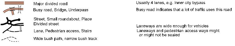
Note: The road and street symbols represent the road and its associated verge/footpaths
Other Man Made Features
Natural Features
Highlight Features

A More Detailed Discussion
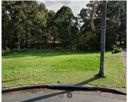
“Open ground” is any natural surface over which the competitor can run confidently. Typical examples would be ovals, parks and nature strips.
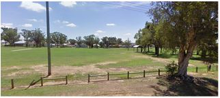
The oval in this photo has been mapped as white on the relevant Street-O map. Even though there are trees around the two “small structures” (in this case picnic tables) on the map it is still marked as “Open Ground - fast” since these trees won’t really hinder your running speed.
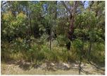
The bushland area between residential areas shown in this photo has been mapped as “Vegetation - slow” on the relevant Street-O map. The mapper feels that the competitor would not be able to run unimpeded through this area.
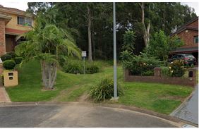
The vegetation in the area between the houses shown in this photo is such that the mapper feels that the competitor would have to slow to a walk and “push" their way through. Thus this area has been mapped as “Vegetation - very slow”.
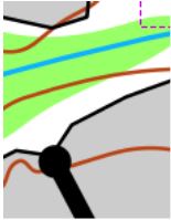
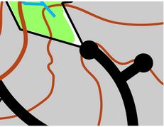
An “Out of Bounds” area on a Street-O map indicates that the competitor is NOT allowed to enter this area. It is used for all residential areas but is also used for open areas that the public are NOT to enter, e.g. private paddocks, cemeteries, golf courses etc.
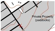

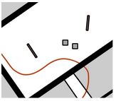
For example, at the red X on the Street-O map, on one side the Out of Bounds area are all private residences but on the other side the Out Of Bounds area is a private paddock. In either case, competitors are NOT allowed to enter these areas.
Sometimes it might be tempting to ignore the Out Of Bounds indication on the map and to enter/or cross such areas. Obviously, this is not in the spirit of the event but more importantly we want to be “good” citizens and not be a nuisance in the suburbs that we use. So, DON’T DO IT! And remember, with MapRun we can check the routes of the entire field in one quick-to-run animation where it will be obvious if anyone is cheating.
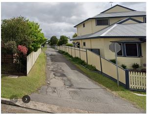
5. Laneways and Pedestrian Access Ways
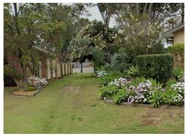
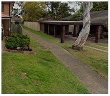
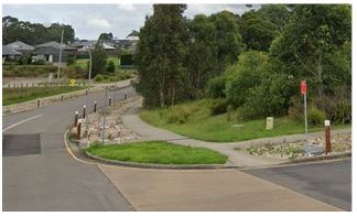
The laneway symbol is used to represent access ways that are (potentially) used by vehicles but are not wide enough to be classified as a street. In most cases they are sealed, as shown in the photo on the left. However the access way shown in the photo on the right has also been mapped as a laneway.
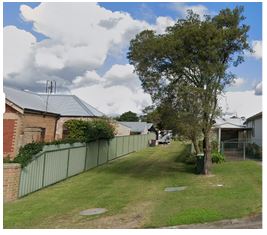
Access ways that are suitable only for pedestrians (or push bikes etc.) are mapped using the Pedestrian Access symbol. Again, these access ways may be sealed, (e.g. concrete footpath, a cycleway etc.) but could be just a grass passageway or similar. All of the access ways shown in photos below have been mapped as pedestrian access ways.
Overall
- Overall Street Series Co-ordinators: Samantha Howe, Malcolm Roberts
- MapRun Administrators: Stuart Kurtz, Malcolm Roberts
- Mapping Committee: Andrew Killen, Adrian Plaskitt, Malcolm Roberts
- All Things Money: Joy Guy
Before Each Event
- Event Course Setter: 18 of these needed each season (1 WarmUp event, 17 Street events)
- Eventor Set-up: Malcolm Roberts
- Website Update: Glenn Burgess, Malcolm Roberts
- Facebook Update: Geoff Peel
- Map Printing: Jeff Guy
At An Event
- Set Up: Event course setter
- Registration/Finish: Joy Guy, Event course setter
- PreStart Area: Jeff Guy
After An Event
- Official Results and Series Totals: Malcolm Roberts, Trevor Wells
- Posting Results: Malcolm Roberts, Trevor Wells
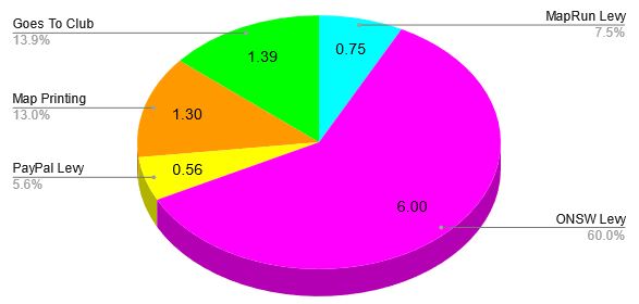
As with any event there are costs associated with putting on the event that must be covered by the entry fee for the event. The chart below shows where the entry fee for an individual member goes.